Open
Ground imagery comes from ZOD and Mapillary, paired with aerial imagery from national mapping agencies with open access.

ECCV 2026 (Spotlight) Sep 11, 2026 · Spotlight Presentation 9:25 AM CEST · Poster Session 3, #141, ExHall Poster, 10:30 AM CEST
1 École Polytechnique Fédérale de Lausanne (EPFL), Switzerland 2 Southern University of Science and Technology (SUSTech), China 3 Delft University of Technology (TU Delft), The Netherlands 4 Zenseact
Ground imagery comes from ZOD and Mapillary, paired with aerial imagery from national mapping agencies with open access.
The dataset combines calibrated vehicle-mounted sensors with in-the-wild images from pedestrians, cyclists, cars, and other capture platforms.
OpenCVL covers four countries, 41 cities, more than 7,000 km2, and 617,388 ground-aerial image pairs.
OpenCVL spans Sweden, the Netherlands, Poland, and Norway. Each ground-level image is paired with a 100 m by 100 m aerial crop from national open mapping sources.

Vehicle-mounted front-facing cameras, LiDAR, and high-end GNSS provide accurate pose supervision for training and curated evaluation.
274,487 imagesCrowd-sourced street-level imagery adds broad variation in camera type, mounting, viewpoint, time, weather, and scene content.
342,901 imagesAerial crops are retrieved from national open-data mapping sources for Sweden, the Netherlands, Poland, and Norway.
0.04-0.16 m/pixel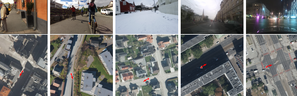
Training split
Combines ZOD and Mapillary ground imagery to scale supervised learning with both accurate pose supervision and broad viewpoint diversity.
@inproceedings{opencvl2026,
  title = {OpenCVL: An Open, Diverse, and Large-Scale Dataset for Fine-Grained Cross-View Localization},
  author = {Xia, Zimin and Zaffar, Mubariz and Fu, Junsheng and Alahi, Alexandre and Kooij, Julian F. P.},
  booktitle = {European Conference on Computer Vision},
  year = {2026}
}